
Technical Overview
This technical study explains how SINS, GPS, odometry, and barometric altitude data can be fused through federated Kalman filtering to maintain accurate, fault-tolerant vehicle navigation in complex urban environments and during short GPS outages.
To address the susceptibility to interference and reduced positioning accuracy of individual navigation systems in complex urban environments, this paper proposes a vehicle-mounted integrated navigation method based on multi-source information fusion and federated Kalman filtering.
The method uses a Strapdown Inertial Navigation System (SINS) as the primary reference system and integrates three additional heterogeneous sensor inputs: the Global Positioning System (GPS), odometer (ODO), and barometric altimeter (ALT). Together, they form an open four-source fusion architecture with fault diagnosis and system reconfiguration capabilities.
The federated filtering architecture successfully implements fault isolation and system reconfiguration, significantly improving the autonomy, robustness, and adaptability of vehicle navigation systems in complex environments.
At Andelu, we use this framework as a technical reference for developing and selecting vehicle-mounted inertial and integrated navigation solutions
Keywords: Multi-source information fusion; Federated Kalman filtering; Adaptive information allocation; Fault detection
Key Findings
- The proposed architecture combines SINS, GPS, odometry, and a barometric altimeter in an open four-source fusion system with fault diagnosis and system reconfiguration.
- When GPS signals are available, both horizontal and vertical positioning accuracy remain better than 10 m in the reported simulation.
- During a 60-second GPS outage, the SINS/ODO combination keeps horizontal positioning error within 10 m, while the altimeter suppresses altitude-channel divergence.
- Adaptive information allocation and residual-eigenvalue fault detection improve system robustness. The reported gradual-fault detection speed increases by approximately 50%.
1. Introduction
1.1 Research Background and Significance
In complex urban environments, precise ground navigation relies heavily on high-precision and highly reliable vehicle-mounted integrated navigation systems.
This is because individual navigation systems have inherent limitations:
- Inertial Navigation System positioning errors accumulate and diverge over time.
- GPS/GNSS signals are susceptible to obstruction and interference.
- Odometer errors accumulate as the driving distance increases.
- Barometric altimeters provide absolute altitude information but have limited accuracy and are affected by meteorological conditions.
Therefore, fusing information from multiple heterogeneous navigation sensors to achieve complementary advantages has become a core research direction in vehicle-mounted integrated navigation technology.
Compared with centralized filtering, a federated architecture divides the high-dimensional estimation problem into several parallel sub-filters. This reduces the computational burden and prevents a fault in one aiding sensor from directly contaminating the estimates generated by the other navigation channels.
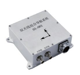
1.2 Current State of Research at Home and Abroad
The development of vehicle-mounted integrated navigation technology began earlier outside China. Represented by the SIGMA30 system from France’s SAGEM, this technology combines a laser gyro-based strapdown inertial navigation system with an odometer, achieving positioning accuracy of up to 0.05% of the distance traveled.
Systems such as the TALIN series from Honeywell in the United States and the FIN3110 from the United Kingdom possess INS/ODO autonomous navigation capabilities in GPS-denied environments.
Regarding altitude-channel processing, the SINS/ALT combination has become a conventional solution for suppressing altitude divergence.
Research in China began in the 1980s. In recent years, considerable progress has been made in areas such as laser gyro-based inertial navigation systems and fiber-optic gyroscopes. However, further improvements are still needed in the architecture of multi-source information fusion systems, fault-tolerance mechanisms, and plug-and-play capabilities.
2. System Architecture Design for Multi-Source Information Fusion
The open multi-source information fusion architecture designed in our study is shown in Figure 2.
The system uses a Strapdown Inertial Navigation System as the common reference frame. It forms parallel sub-filters with the odometer, GPS, altimeter, and other sensors.
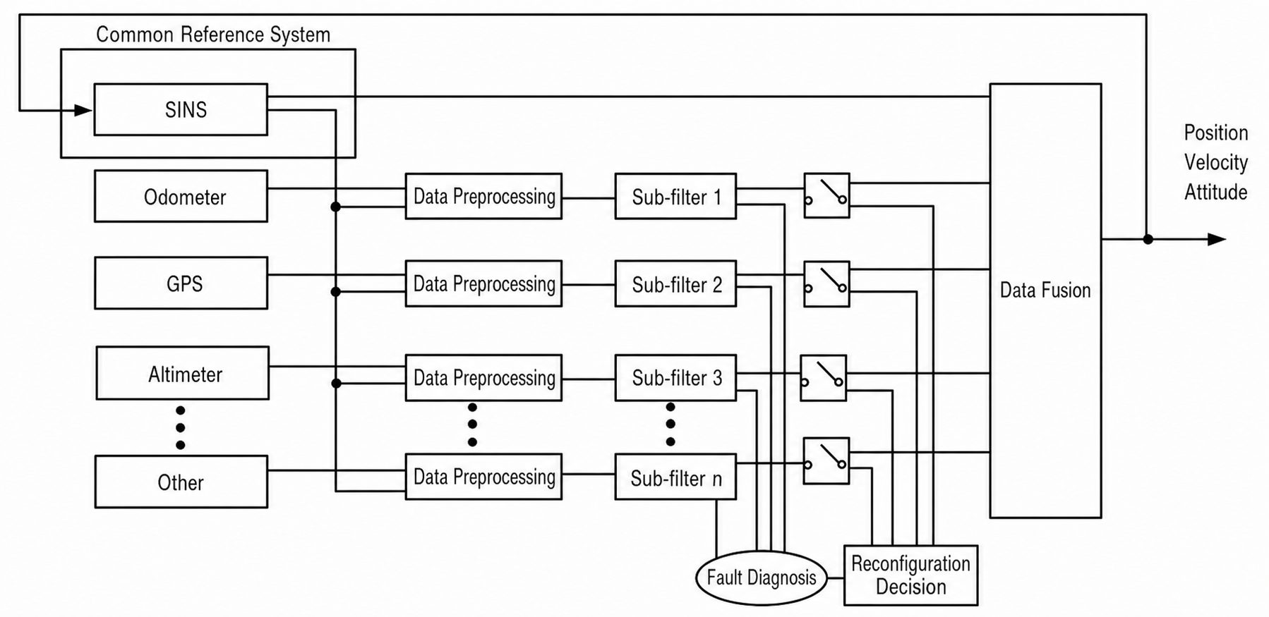
After preprocessing, the data collected from each information source are sent to the corresponding sub-filter. Each sub-filter independently performs local state estimation.
The output of each sub-filter is checked by the fault diagnosis module. The reconstruction decision mechanism then determines whether the result should be included in the main filter’s data-fusion process.
Finally, the system obtains optimal estimates of the vehicle’s position, velocity, and attitude through the data-fusion module.
3. Mathematical Model of the Multi-Source Integrated Navigation System
3.1 Definition of Coordinate Systems
This study adopts the following coordinate systems:
Inertial coordinate system (i-system): Earth-centered inertial coordinate system.
Earth coordinate system (e-system): Earth-centered, Earth-fixed coordinate system, or ECEF.
Navigation coordinate system (n-system): East-North-Up geographic coordinate system, or ENU.
Body coordinate system (b-system): Right-Forward-Up coordinate system, or RFU.
Odometer coordinate system (m-system): A coordinate system with a small angular installation deviation relative to the body coordinate system.
3.2 SINS Error Equations
The 15-dimensional error-state vector of SINS is defined as:

In this vector:
- φ represents the attitude error.
- δV represents the velocity error.
- δP represents the position error.
- ε represents gyro drift.
- ∇ represents accelerometer zero bias.
The attitude error equation is:

The velocity error equation is:

The position error equation is:



3.3 SINS/GPS Sub-Filter
The SINS/GPS sub-filter employs a loosely coupled velocity-and-position fusion mode. Its measurement equation is:


To account for the lever-arm effect, the positional offset between the GPS antenna phase center and the IMU center must be compensated.
The state variables of the sub-filter are set to 18 dimensions. They comprise the 15-dimensional SINS error state and the three-dimensional GPS lever-arm error.
3.4 SINS/ODO Sub-Filter
The odometer uses a distance-increment output method. Its measurement model is:

By incorporating the odometer scale-factor error, installation-deviation angle, and lever-arm error as state variables, a 21-dimensional SINS/ODO integrated navigation model is established.
The system uses the difference between the one-second inertial-navigation position increments and the dead-reckoning position increments as the measurement value. This approach effectively mitigates the noise amplification caused by velocity differentiation.
The position-increment measurement also avoids directly differentiating odometer distance measurements to obtain velocity. Because differentiation can amplify measurement noise, the increment-based formulation is more suitable for vehicle navigation systems using pulse-output odometers. Estimating the odometer scale factor, installation angles, and lever-arm error further reduces systematic errors caused by tire variation and mounting uncertainty.
3.5 SINS/ALT Sub-Filter
The state variables of the SINS/ALT sub-filter are selected as the 15-dimensional error states of the SINS system.
The difference between the altitude calculated by SINS and the altitude measured by the barometric altimeter is used as the observation:

3.6 Federated Kalman Filter
The global optimal fusion algorithm of the federated Kalman filter is expressed as follows:


The information distribution must satisfy the principle of information conservation.

To improve fault tolerance, this study adopts a feedback-free, reset-type federated filtering structure. This structure prevents a failure in one sub-filter from contaminating other channels through feedback.
4. Key Technologies and Algorithms
4.1 Adaptive Information Allocation
Traditional federated filtering usually employs equal information allocation.  However, this method does not account for differences in the noise characteristics of individual sensors.
This study proposes an adaptive information-allocation method based on predicted residuals.
The residuals are first defined. Their theoretical covariance and actual covariance are then calculated and used to construct an adaptive factor:

,



After normalization, the adaptive information-allocation factor satisfies the principle of information conservation.
This method allows the system to assign information dynamically according to the operating condition and reliability of each sensor, rather than assigning an equal weight to every information source.
4.2 Improved Fault Detection Algorithm
Traditional residual-detection methods are not sufficiently sensitive to slowly developing faults. To address this limitation, this study proposes an improved detection algorithm based on eigenvalue analysis.
First, the residual matrix is constructed. The residual covariance matrix is then calculated, and its largest eigenvalue is selected as the detection statistic.
Construct the residual matrix: 

Define the residual covariance matrix as: 
The largest eigenvalue of , denoted by
  , is selected as the detection statistic. To improve the stability of fault detection, a sliding-window average is applied:

The fault-detection criterion is:

If the detection statistic exceeds the threshold \(T_D\), the system determines that a fault has occurred.
5. Conclusions
This study proposes a vehicle-mounted integrated navigation method based on multi-source information fusion and federated Kalman filtering.
The main conclusions are as follows:
Comprehensive multi-source fusion architecture
Federated filtering is employed to achieve four-source fusion of SINS, GPS, ODO, and ALT. The resulting architecture supports fault diagnosis, system reconfiguration, and plug-and-play operation.
Adaptive federated filtering
Adaptive information-allocation factors are designed based on predicted residuals. This approach overcomes the limitation of traditional equal allocation, which ignores differences in sensor noise.
Improved fault detection
An improved fault-detection method based on residual eigenvalue analysis increases the detection speed for gradual faults by approximately 50%.
Overall, the proposed architecture improves vehicle-navigation autonomy, positioning robustness, and adaptability in complex environments, particularly when GPS signals are temporarily obstructed or interrupted.
References
[1] Yan Gongmin. Research on Vehicle-Mounted Autonomous Positioning and Orientation Systems [D]. Northwestern Polytechnical University, 2006.
[2] Zhang Jing. Research on Vehicle-Mounted Positioning Technology Based on Multi-Source Information Fusion [D]. First Academy of China Aerospace Science and Technology Corporation, 2018.
[3] Fu Qiangwen, Qin Yongyuan, Zhou Qi. “An Improved Measurement-Based Vehicle-Mounted Strap-Down Inertial Navigation/Odometry Integrated Navigation Algorithm” [J]. Measurement and Control Technology, 2013, 32(7): 134–137.
[4] Qin Yongyuan. Inertial Navigation [M]. Beijing: Science Press, 2006.
[5] Gu Tao, Chen Shuai, Tan Juhao, et al. “Research on a Multi-Source Integrated Navigation Algorithm Based on SINS/GNSS/OD/Altimeter Using Federated Filtering” [J]. Navigation and Control, 2021, 20(3): 20–26.
[6] Li Bofeng, Chen Guang’e. “A Method for Cooperative Precise Positioning of Vehicles Using GNSS/INS Integration” [J]. Acta Geodaetica et Cartographica Sinica, 2022, 51(8): 1708–1716.
[7] Li Bing, Zhan Xingqun, Zhan Lei. “Research on Vehicle-Mounted Integrated Navigation Based on GPS/SINS/Odometer” [J]. Measurement and Control Technology, 2012, 31(11): 43–47.
[8] Yan Gongmin, Weng Jun. Strap-Down Inertial Navigation Algorithms and Principles of Integrated Navigation [M]. Xi’an: Northwestern Polytechnical University Press, 2019.